Wednesday, 1 October 2014

Stonehenge: A Few Scary Moments On The A303 At Stonehenge Bottom

Earlier today, I went for a bike ride to clear my head and for the last part, I rode north-eastwards along Byway 12, to the A303.  Crossing the A303 is never easy and you need to have your wits about you.  Putting it bluntly, when you cross the A303 here, you have to remember that the great travelling public aren't really thinking that they might encounter people by the roadside.  Why on earth would there be people close to one of the wonders of the World; I ask you?

As a consequence of this, anyone attempting to cross the A303 at Byway 12, Byway 11 or Stonehenge Bottom has to regard themselves as a slice of ham about to be sandwiched between two pieces of steel-reinforced "bread" with a closing speed in excess of 120 mph.  Get it wrong and it is going to hurt - briefly, bloodily and almost certainly, finally.

At Byway 12, you have to wait until you can't see vehicles in either direction to have enough time to stroll, not run, across the A303.  Running isn't advised, as if you were to fall, you simply wouldn't have time to pick yourself up before the Grim Sandwich Maker appeared.  On quiet days, you might have to wait a couple of minutes for a safe gap - there aren't many quiet days any more!  On a bad day, you might have to wait 10-15 minutes or even longer to cross in reasonable safety, or simply give it up as a bad job and back track. Too many lose patience and take silly risks...

Today wasn't too bad and I was safely across in under a minute.  I rode up to the A344 then onto the temporary permissive path between Byway 12 and Stonehenge Bottom.  As I crested the ridge down to Stonehenge Bottom I was confronted by a veritable gaggle of cyclists heading down towards the A303.


They were a nice friendly bunch and I explained that I was part of STAG and what we were about and please could I take photos of them if they were trying to cross.  They were happy for me to do so, so here is a short vignette of what happened next.

The thought of them all trying to cross made my blood run a bit cold as the traffic here is gravity-assisted in both directions and the westbound traffic is still trying to settle scores with other drivers from the 2 lanes into 1 section of the A303, a few hundred meters to the east.

A few cyclists at the front of the group spotted a small gap and either ran or rode across.

Most of them didn't get the opportunity and there was  steady stream of fast-moving traffic in both directions on what is, at this point a Clearway, not that anyone gives a tuppeny-damn about the Highway Code these days!

They waited, and waited, and waited.
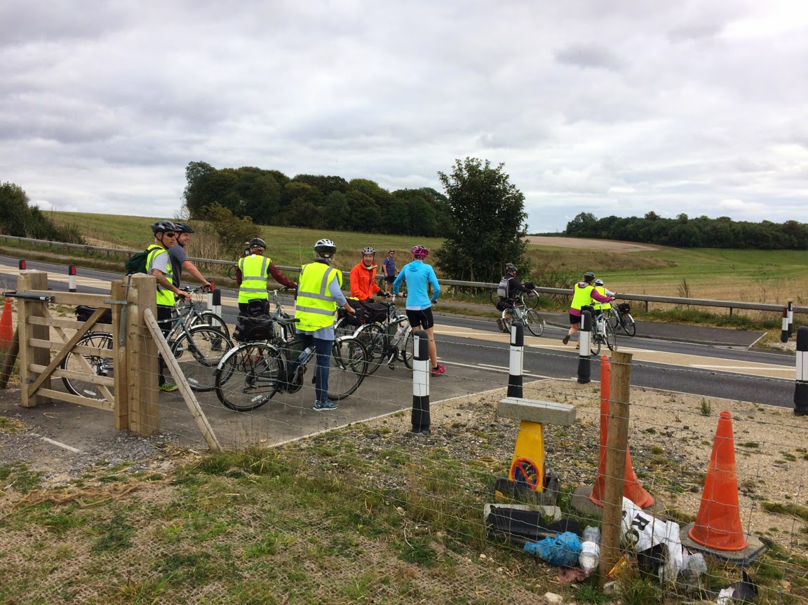
When a westbound gap appeared they moved forward, then back again as it disappeared.

One of them made it to the central strip and an eastbound driver in a grey car slowed and stopped.  Remember, it is a Clearway - no stopping.

The cyclists, not quite sure what to do now, all started to move off the verge towards the centre of the A303,  but did so very hesitantly.  The westbound traffic was still thundering past them with mere inches to spare.  It couldn't have been a very pleasant experience.

White van man from Black Hole Storage Removals clearly didn't give a damn and went roaring through and this carried on for a while until another grey car stopped on the westbound carriageway.
and finally, the whole group got across safely.

It could so easily have been very different.  But why are things so dangerous?

Well, the people who control the World Heritage Site have a policy of making Stonehenge a more bike (and horse and pedestrian) friendly place.  This seemed to be borne-out in the plans for the new visitor's centre submitted by English Heritage.  However, despite their intentions and despite planning conditions that mandated a whole raft of measures that would have improved things for cyclists, English Heritage have singularly failed to deliver.

One of the few things that was largely outside the control of English Heritage was an improved crossing at Stonehenge Bottom.  On the one hand,  increased usage of the crossing point was anticipated by all parties after the closure of the A344, hence the planning requiremnt.  However, a spoke was put in the works by the Highways Agency who produced a report - in the way Government Agencies do when they don't want to take action.  The conclusion of this report reads as follows:


"It is the designer’s view that the current usage of this crossing by pedestrians or by cyclists, on either the A303 or the A344 routes, does not justify the increased risk to motorised users on the A303 of providing refuge islands for this crossing. However it is felt that the opportunity to relocate the crossing to the best location position for NMU visibility and to reduce the crossing width is justified and should be taken.

In taking this view, the designer is taking note of RSA team preference, based on pedestrian rather than cycle use of the crossing, of the do minimum crossing type. The designer is also influenced by the fact that this is far from being the only single carriageway rural at grade crossing of the A303 with no specific NMU facilities, including equestrian crossings. 

The proximity of this crossing to the Stonehenge World Heritage site does not currently attract to it significant NMU usage. It is therefore felt that neither the existing usage of the crossing or the last five year’s accident records warrant a different approach here to that taken at other similar crossing locations where the balance of risks between NMU and Motorised Users, and hence the actual overall risk, dictates the level of provision made. 

It is therefore recommended that the measures in Option 4 proposals, with the refuge islands removed but all the other measures retained is adopted. 

A future scheme for reviewing the crossing arrangements needs to be submitted and approved. The scheme shall have regard to Design Manual for Roads and Bridges HD 19/03 Stage 4 Safety Audit 12 and 36 month post scheme recommendations for any remedial action. 

It is felt that the extensive investigation already under taken into the examination of the safety of and the changes to the crossing here proposed satisfies the requirements of the planning condition."

Just for the record, NMUs are non-motorised units - pedestrians, cyclists and horse riders.  Cutting out all the crap, what they are actually saying is that the body-count at Stonehenge Bottom is too low to warrant making anything more than superficial changes. However, they go on to suggest that a safety audit at 12 and 36 months might change things if the body count increases.

I don't suppose the contribution by Wiltshire Council helped much either:


"...that in relation to cycle usage their preferred route between the A344 to the north and Amesbury for cyclists was via the countess roundabout underpass crossing of the A303 and than via Lark Hill."  (all the typos and grammatical errors are courtesy of the Highways Agency!)

As usual with Wiltshire Council when it comes to anything in the south of the county - thumbs up bums and brains in neutral all the way.  No-one in their right minds, who knew about the local area, would ever choose to get from the centre of Amesbury to Stonehenge by heading north, through the scrofulous Countess Roundabout underpass (on foot - as cycling is forbidden on this bit of the cycle route), up Countess Road, being harassed by rat-running motorists, then head west to Larkhill along the rat-run of choice for coaches and HGVs, before eventually getting to the northern end of Byway 12.

Most sensible folk will simply head out to West Amesbury, up to the A303 and then to Stonehenge Bottom and the A344 - no need to ride with high speed traffic at all - just dice with death crossing the A303.  That's what they've always done, that's what they were doing today and that's what they will do until the A303 issue is resolved once and for all. 

Of course,  there was a fall-back plan to monitor the situation.  Here it is.  Read it carefully and spot the flaw:


STONEHENGE ENVIRONMENTAL IMPROVEMENTS PROJECT Planning Application Reference S/2009/1527 

Scheme required under planning condition 27 for reviewing pedestrian and cycle route access arrangements along the whole of the A344, and crossing arrangements at the A303 (Stonehenge Bottom)

Following approval of the details of the pedestrian and cycle route access arrangements along the whole of the A344 and crossing arrangements at the A303 (Stonehenge Bottom), English Heritage will co-operate with the Local Highways Authority, Highways Agency and the Local Planning Authority in reviewing the arrangements. In particular, should a formal Stage 4 Safety Audit be carried out, and any recommendations for remedial action be made in the 12 and 36 month Stage 4 Reports submitted to English Heritage and the other organisations, then any required remedial works, and arrangements for their implementation and funding, will be considered and agreed between English Heritage, the Local Highways Authority, the Local Planning Authority and the Highways Agency, as appropriate. 

In addition, English Heritage will carry out the following:

  • -  Incorporate questions about the pedestrian and cycle access into the annual visitor survey conducted by the travel and tourism department of market research company TNS. This will comprise face to face interviews with 180 individuals during the months of July, August and September. Likely questions include: whether people have accessed the site on foot or on bicycle, and, if so, where they have travelled from, how satisfactory they have found the route and where they are travelling onto. 

  • -  As part of the ongoing operational management of the site English Heritage staff will, as a matter of course, record, report to the relevant authorities and, if appropriate, take any necessary action in respect of any incidents or accidents along the route of the A344 between Airman's Corner and Stonehenge Bottom. 

    English Heritage 26th April 2012
 
Did you spot it?  Yes, that's right.  Most pedestrians, cyclists and horse riders arriving at Stonehenge don't pitch up at the visitor's centre, as there is (still) no provision for them.  They may arrive from east or west, north or south, but we suspect that few, if any, will be invited to take part in the annual visitor survey, conducted for English Heritage by TNS.  
During my many visits to the WHS this July August and September I've never seen anyone with a clipboard interviewing pedestrians, cyclists and the two riders I have seen, nor have I ever been approached.  Now that's interesting, if true because this safety audit is meant to be looking at the safety of crossing the A303 by any and all users, not just English Heritage's paying customers.
As I say, we don't know for certain that this is the case, but I feel an FOIA request ,or two, coming on! 


Thursday, 25 September 2014

Stonehenge: What English Heritage Told Wiltshire Council They Would Do To Discharge Planning Conditions - Then What They Failed To Do!

Over the last few weeks we have highlighted our concerns that English Heritage might have failed to discharge their obligations in relation to the planning conditions imposed on them by Wiltshire Council, in allowing the construction of the new visitor's centre at Stonehenge, which opened in December 2013.

Suspicion is one thing, having evidence is something else entirely.  Consequently, we submitted a FOIA request to Wiltshire Council using the What Do They Know website to make life easier.   Basically, in granting planning consent, Wiltshire Council had imposed 27 separate conditions that English Heritage were required to adhere to, covering a wide variety of topics associated with the new buldings, the environment and the A344.  It would have been unreasonable for us to have asked about them all given our interests, so we restricted ourselves to those conditions that dealt directly with the use of the A344 by pedestrians and other users.

Wiltshire Council had told English Heritage to provide detailed plans for how they were going to ensure the planning conditions were met.  Wiltshire Council would then approve these proposals before they were instituted.  All very sensible and logical.

The information we got back from Wiltshire Council was a bit of revelation.  You can download it and study it yourself from here.  Wiltshire Council also indicated that they would put the same information on their website to aid its easy retrieval in the future.  So here, in a nutshell, is what we discovered.


In early 2012, CBA Associates, acting for English Heritage, proposed to Wiltshire Council that the outstanding planning conditions be discharged.  In reply, in two separate letters on 13th and 25th June 2012, Adam Madge of Wiltshire Council Planning Department responded to this proposal, agreeing to the measures English Heritage had put forward to comply with these obligations and in both letters stating:

"I would confirm that the details sent to us in relation to these conditions are acceptable to the local planning authority. The conditions will have been fully discharged when the development is carried out in accordance with these details as submitted.”

In other words, providing English Heritage complied with what they themselves had proposed, they would have satisfied Wiltshire Council.

So let's take a look at a few of the details, using English Heritage's own timetable:


PHASE 1 – STONEHENGE BOTTOM – MARCH 2013 – JUNE 2013


A new permissible route for pedestrians and cyclists is to be installed with the section that crosses the A344 being reinforced with a plastic ground reinforcement grid and defined by a low barrier, such as a rope barrier to stop visitors walking on the establishing areas of grass.


FAILED: Although the ground reinforcement was installed as planned, no route was marked until late summer 2014.  Even now, the route marking is all a bit half-hearted and may be incorrect.


PHASE 2B – ENTRANCE CONFIGURATION – LATE SEPTEMBER 2013


On the A344 west of Byway 12 a section of the A344 is removed and reinforced hardwearing turf established. Site hording, such as Heras fencing is erected prior to the works beginning and is replaced by a temporary barrier/fence on its completion. These areas of hardwearing grass will be released in Sumer 2016.

New gates, Kent carriage gap and fences are to be installed at the intersection of Byway 12 and the A344.


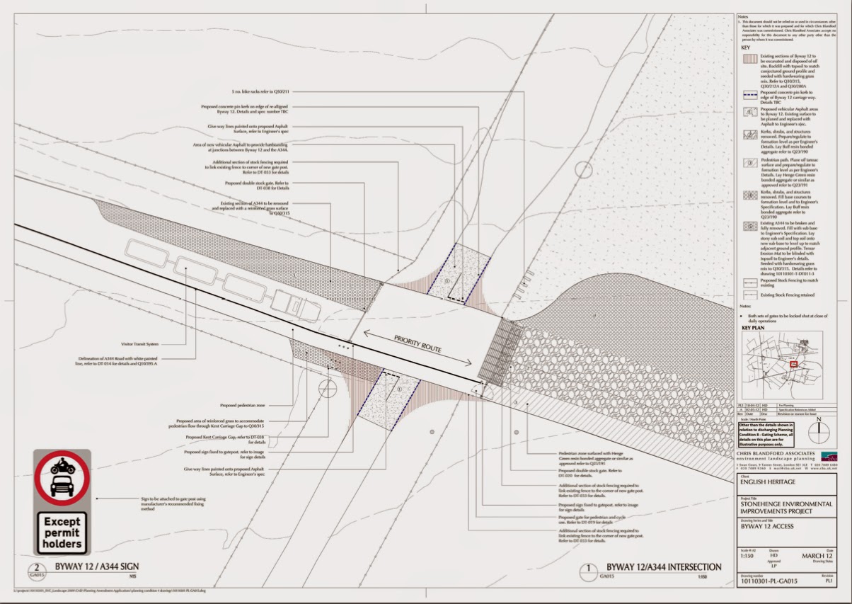
FAILED:  The following diagram shows what EH said they would install - Kent Carriage Gaps of the dimensions we have harped on about several times:


This is a bit hard to see, so here is the detail:


The design of the Kent Carriage Gaps, proposed by EH and accepted by Wiltshire Council, was:


You may also note in the plan above, that EH were supposed to provide cycle racking by certain deadlines they themselves had proposed:


Cycle Parking and Storage Provision at the Western End of the retained A344

10 no. bicycle racks to accommodate the parking/storage of 20 cycles will be provided in the location shown on drawing 10110301-T-GA003. These will be installed during works to the A344 in a 12 week construction period currently scheduled to commence on 06/03/2013 and complete on 05/06/2013.


FAILED


 Cycle Parking Provision at the Eastern End of the retained A344

5 no. bicycle racks to accommodate the parking of 10 cycles will be provided in the location shown on drawing 10110301-T-GA005. These will be installed during the construction of the Hub Building and Visitor Transit System Drop-Off/Pick Up area in a 24 week construction period currently scheduled to commence on 09/10/2013 and complete on 08/04/2014.


FAILED

Work should have also been carried out last year at the intersection of Byway 12 with the A344

The intersection of the A344 and Byway 12 and road surfaces of both the north and south approaches of Byway 12 will be planed and resurfaced with tarmac. A traffic management programme will be carried out while these works are being completed to allow traffic along the A344 as needed.


FAILED: EH have failed to install Kent Carriage Gaps, gates and cattle grids at the intersection.  Anyone would think they were holding back in case Byway 12 was closed!
Where things get really confusing is in relation to the permissive path for cyclists and pedestrians between Byway 12 and Stonehenge Bottom.  English Heritage, in proposing to discharge planning condition 11 noted to Wiltshire Council in a general statement:


A permissive path (for pedestrians and cyclists) will be available on National Trust land immediately north of the Stonehenge monument running along the line of the former A344 between Byway 12 and Stonehenge Bottom.

Completely unambiguous, what was reported by the Press at the time, completely reasonable, but NOT what English Heritage actually intended.  Between now and 2016, the temporary permissive route will follow its current course:


It follows the northern side of the stopped-up A344 to a new gate in the northern stock fence, crosses through the stock fence into the National Trust open access land.  Now here is the idiocy.  Once you are through the gate, you don't need to stick to the path and indeed one of the points the National Trust often make about this type of open access land is that they prefer people didn't all keep to one path, as it does less damage to the terrain.  So having permission to use a path over land over which you have permission to roam does seem a wee bit superfluous.  But it is, allegedly, only a temporary arrangement.


PHASE 4 – STONEHENGE BOTTOM – SUMMER 2016

The existing/temporary stock fence and gates to the north of the original A344 are to be removed and turf used to patch any resulting disturbances in the grass surface. The areas of the permissible route that are formed using the ground reinforcement system are to be removed and patched using turf grown off site.

The permissible route is now along the northern edge of the re-vegetated A344.


PARTIAL FAIL: The unambiguous brief answer provided by EH was highly misleading.  The detailed answer may turn out to be correct, but we wont know until 2016.

We said at the outset that we had only asked about a few of the planning conditions that were imposed by Wiltshire Council, but our findings are worrying as it suggests there may be a systematic problem with the way these have been dealt with by English Heritage.  It also highlights what some might perceive as a lack of diligence on the part of Wiltshire Council's Planning Department.  The question has to be asked as to why they haven't been closely monitoring work at what must be one of Wiltshire Council's most prestigious locations and one of national and international importance.

We've now fed this back to Wiltshire Council.  They need to put their house in order - and do it quickly.  Only then might we see the quality of development at Stonehenge that English Heritage promised and that so farm they have singularly failed to deliver.


Saturday, 13 September 2014

More Mistakes By English Heritage, Or Is It Intentional Rather Than Merely Incompetent?

Purely by chance, there was a veritable rangale of STAGs up at Stonehenge on Thursday 11 September.


It all started first thing in the morning when we received a phone call from Watch Bustard, who had been up at sparrows (for the benefit of our foreign readers, sparrows is a contraction of sparrow-farts, a north of England term for the crack of dawn) and had noticed an unusual amount of activity around the Kent Carriage Gap at the western end of the A344.  He promptly called us here at WiSBAng and his good lady, to let us know something was afoot.

As we had promised to go and measure a few things, we cycled up to Stonehenge, armed with a tape-measure and notebook to take a look see.  Here is what we found.  A week ago, the first gap looked like this.

This week (Courtesy of Watch Bustard) it looked like this.

As far as we can see, the only changes are the removal of the safety fencing and the possible laying down of a few scalpings on the surface - but this may just be a trick of the light.  Any progress has been minimal.

UPDATE: The ever-watchful Watch Bustard noted on Monday 15 September that tarmac appeared to be in the process of being laid around these carriage gaps.  A good way to compound the errors that are highlighted in the following paragraphs.

We really wanted to check to see if the dimensions of the gates were compliant  with the Kent Carriage Gap (KCG) standard that we illustrated in an earlier post.  The idea is to have two sets of posts, the shorter pair in the centre being just wide enough to allow small carriages to pass between them and the outer ones allowing larger ones, with greater axle heights, to pass over the inner posts.


So, what have English Heritage achieved.  Well, the posts are 0.24 metres tall instead of the 0.33 metres tall for a KCG.  The separation of the inner posts is 1.83 metres instead of the KCG standard of 1.52 metres (6 ft in real money) and the distance between the inner post and the kerb edge in the photo above is 36cm and between the inner post and the gate post 41 cm.  This dimension should be 0.6 metres for a KCG.  We won't even mention the suggested second and third rows of posts ).45 metres from the first as EH haven't bothered with at all.


The second KCG on the A344 is somewhat similar to the first.  The gap between the inner posts is 180cm, with a hefty 2.17 metres to the left and a few cm to the right of the inner posts

This all looks a bit amateurish and half-hearted on English Heritage's part.  Almost as if they didn't want to have these here in the first place and that anything will do as a sop to those who might raise the issue. 

To cheer ourselves up, we rode down to the stones and then proceeded eastward on the temporary permissive path over National Trust open-access land (isn't a path a contradiction in terms here?).  Typically, the first sign to tell you what the path is, is only found when you are on the path.  Surely, it would make sense to signpost it from the A344?

On we went, down towards Stonehenge Bottom to see how things were progressing here.  Readers may recall that another planning condition imposed on English Heritage was that a permissive byway be instituted along the course of the stopped-up section of the A344, back to Byway 12.  A few months ago, English Heritage claimed that the reason the permissive byway hadn't been opened was because of bad weather over the winter and it would take over a year for the grass to grow.  Needless to say, the byway should have been opened on the A344 route before the Visitors Centre was opened and the bad weather of winter 2013-24 only struck a few weeks after this point.  Not ones to let facts ruin a tall tale are English Heritage.

Here is the view eastwards from where the diversion meets the intended route towards Stonehenge Bottom.  Another failed planning condition as well - a safe pedestrian route over the A303.

As you will see, the growth of vegetation here has been pretty poor.  Superficially, this might support English Heritage's contention that the climate was responsible for the time that was going to be needed to allow grass, etc to become established.  Here again, as with any statement regarding the A344 by English Heritage, it's always worth taking a closer look.


Now on the left of the picture above, there is a plastic mesh sunk into the ground to prevent heavy traffic from destroying the grass and rutting the surface:

You will see that this is pretty typical soil for this neck of the woods, with large numbers of chalk and flint fragments on the surface.  Between a quarter and half of each segment is taken up by surface rocks and so there isn't a great deal of space for plants to take root and grow - and they haven't.

The right hand side of the byway-to-be is even worse, with even less plant growth - and most of this is made up of weed species.

Here, a hessian mesh has been used to cover the surface.  Whoever dreamt this one up had either not understood the nature of the soil here, or was actively trying to prevent plant growth.  Basically, the holes in the mesh are smaller than the bits of flint and chalk on the surface, so large numbers of the holes are unavailable for even the most persistent plants to grow through as they are blocked by rock.  You can see the consequences. Nice one, English Heritage!

They couldn't get things even more wrong, could they?  Well, we are talking English Heritage aren't we.  Returning to Byway 12, we noticed this, close to the Heel Stone.

It all looks, well, a bit, yellow.  Our first thought was that the dry weather had killed off the growth, but as before, it pays to look closer.


Stunning, they have covered the surface in sand and, surprise, surprise, nothing much is growing.  Nothing much is likely to grow for a long time either.  Yet again, English Heritage appear to have done everything they can to fail to comply with Wiltshire Council's planning requirements and ensure that as few people as possible approach Stonehenge in any way other than going via the Visitor's Centre. 

UPDATE: We wonder if this other bit of English Heritage idiocy is an attempt to lay down a strata to indicate to future archaeologists that everything below the sand is natural and that everything above it is 2013 vintage or later.  If that is the case, then why not seal in the sand layer with a layer of earth, so it won't get disturbed and plants can grow above it.

 This is where WiSBAng met STAG in the shape of Janice Hassett, who had also wandered down to the eastern end of the site to see what was going on.  You can read her account here: http://staga303.blogspot.co.uk/2014/09/eh-letting-us-down-againcontinued.html

There is a worrying and confusing series of signs on the fence as you pass the henge:

Perhaps they have a plan to fit a roof to keep their paying visitors dry in inclement weather? 

It was a lovely afternoon and the STAGs met some smashing folk at both ends of the A344. From the young French couple who had turned up without booking, parked their car at Larkhill and walked in (good to see that someone these days can actually read a map!), to the Welsh primary school kids who were so well-behaved and a credit to their teachers, to the daughter of an archaeologist who had left her to go for a walk around Stonehenge, whilst he went to a Wessex Archeology meeting at Old Sarum.  A good afternoon to get a few more signatories for the STAG petition!

Wednesday, 10 September 2014

Goodwill Hunting - A Little More News of the A303 Feasibility Study


As we said a couple of posts ago, there seems to have been very little activity over the summer regarding the A303/A30/A358 corridor feasibility study, which, given the Parliamentary recess, summer holidays and, for once, a half-way reasonable summer, isn’t all that surprising.  That isn’t to say nothing has been going on.  It seems the study is a bit like a swan on water – not much going on above the surface, but some furious (?) paddling going on below.


Robert Goodwill MP


We are a bit disappointed though.  Back at the start of the year, we (STAG) wrote to the Parliamentary Under Secretary of State at the Department for Transport, Robert Goodwill MP, expressing our interest, as a local pressure group in the Stonehenge area, in getting involved in all stages of the study.  Back in January, Goodwill’s Assistant Private Secretary came back with the following response:

A Minion, but maybe not the correct DfT Minion?


“…We are also conducting national events to gather views from environmental organisations and other motoring and business groups.

We understand your interest in the study and rest assured, we plan to engage more widely with local groups in the next few weeks. I will ensure that you are kept informed”.

An apparent show of goodwill by Goodwill and his trusty minion.   Unfortunately, these were hollow words and there has been no engagement or even contact as promised.

We do get a few snippets from the meetings that are going ahead though.  The latest was held in Taunton just over a week ago. John Glen MP (Con – Salisbury) was the only MP there at the start of the meeting.  Wiltshire Council were represented by Cllr Fleur De Rhe-Philippe and Mr Parvis Khansari.  David Heath MP (Lib-Dem - Somerton and Frome) represented Somerset interests.

John Glen MP

John Glen pressed home the well-considered view that they realised that any solution without a bypass for Winterbourne Stoke, and a deliverable solution at Stonehenge, was not going to make the A303 a reliable strategic route to SW.

David Heath MP

 David Heath seems to have suggested that the DfT should press ahead with improving other bits of the corridor, even if a solution at Stonehenge is too expensive.  To us that smacks of selfish-self-interest and is profoundly illogical; spending lots of public money to improve roads that the majority of users at peak periods will still have to queue to join and to leave.  A case of blinkered vision!  Let’s hope he is taken to task by Salisbury Lib-Dems when he visits the city this week.

All in all, it seems that the officials at DfT don’t want too much detailed information out in the public domain until they have got all the costings sorted out.  It is clear that they are considering more than one potential solution and options for solutions that both involve and don’t involve tunnels of varying lengths, along various routes.   Superficially, at least, it seems they have kept open minds and haven’t yet been forced to accept historic solutions.

In typical government fashion, when some detail does emerge, we might expect to see costings for several different options with a “Do Nothing” option (there are significant costs attached to doing nothing in terms of lost tourist and business) and a “preferred” option or two.  Time will tell.

The good news is that English Heritage and the National Trust seem to be being a little more open-minded than they have been in the past.  On the down-side, the Stonehenge Alliance seem to be less willing to compromise.   Sadly, that is what it will need to come down to, negotiation and compromise by all parties.  

John Hayes MP

 In a further development on Monday this week, John Glen MP took the opportunity to press his case for the A303 improvement with the new roads minister the Rt Hon John Hayes MP (Con - South Holland and The Deepings).  Mr Glen particularly stressed the need to produce a solution for the whole of the A303 corridor and that to improve parts of the A303 without solving the Stonehenge conundrum would be a failure .

Tuesday, 9 September 2014

English Heritage Mess Up on the A344 - Yet Again

Last month we heard from Wiltshire Council, definitively they claim, that the A344 is still the A344 and a highway.  As "A" roads have a legal definition in the UK and that involves joining population centres, carrying motorised traffic, etc, it is patently absurd to continue to list the A344 as an "A" road.  Consequently, this is being taken up with the Secretary of State for resolution.

Meanwhile, on the A344, English Heritage continue to mess up.  As a planning condition for the new visitor's centre, they were obliged to install Kent Carriage Gaps to allow all non-motorised traffic, not banned by the permanent Traffic Regulation Order, to use the A344, unhindered, 24/7.  Like many of the planning conditions imposed on English heritage (around 23 of them) many were supposed to be put in place before the visitor's centre was opened to the public,; the management plan seems to suggest sometinme between October and December 2013.  Yet again, this was a major fail by English Heritage.  Wiltshire Council Planning Department seem to have done little to police these consents, which makes you wonder what they spend their time doing!

Now for those of you who don't know, a Kent Carriage Gap is one of the ways of enforcing a TRO of the sort imposed on the A344.  This is how they should be designed:

Two sizes of post to allow carriages of different sizes to pass along the carriageway.  The separation of the posts and their height is also defined.

The point of these gaps is to allow unhindered access along the carriageway - the operative word here being along.  This is how they should be constructed.

Have English Heritage achieved this?  No, of course not.  Almost 9 months late, this is all they have been able to manage.

Between the new roundabout at Airman's Cross and the entrance to the visitor's centre carpark you have this attempt, photographed by Wiltshire Councillor and Chairman of Winterbourne Stoke Parish Council Ian West and friends,  it certainly doesn't seem fit for purpose, doesn't meet the design of Kent Carriage Gap for which planning consent was given, and wouldn't appear to be able to be used as intended by all the types of carriage it is meant to permit. 

Further along, we come to an even more egregious mess which we photographed last week in the run-up to the presidential visit!

Well, on the plus side, EH have lowered the kerb.  But that is the only positive thing that can be said about it.  The Gap is again to one side of the A344, not across it and there is no clear exit from it back onto the A344.  It's worse than that, bearing in mind that the path running from left to right comes down from the coach park and is the main access for visitors being brought in from that direction.  Now, given these pedestrians are about to cross an open highway, the A344, in very large numbers, you'd think English Heritage would have had the common sense to do a number of things.  First, leading pedestrians onto and across a highway, without warning them they are crossing one is a fairly stupid thing to do; particularly given that many of them are foreign visitors. 

Second, not warning those using the highway that there may be pedestrians about is also pretty lame, so you'd think there might be proper signage on the path and the road, "Look both ways" signs on the footpath, etc, etc, but no such luck.  All in all, when we have our first visitor mown down by a horse rider, horse and carriage or even a cyclist, the negligence on English Heritage's part will be clear.

In writing this, we realise we never actually measured the height and separation of the posts that are there, so we might have to pop up and measure them to be sure.

Ian West and friends also looked at the state of the permissive byway at the other end of the old A344, beyond Byway 12 and towards Stonehenge Bottom.  English Heritage, keen to foster the World Heritage Site's policy of encouraging visits by cyclists have signposted the route:

You've got to admire the lengths they have gone to over the last 9 months to do this!  Of course, if you take the trouble to go down that way,  avoiding the inevitable traffic jam at byway 12...


...you can get a really good view of Stonehenge, without having to pay the extortionate entry charge.  Follow this up with a visit to the museums in Amesbury, Salisbury or Devizes and you will see the best of Wiltshire's archaeology - you don't even need a local resident's pass.

All we can say is that it is a good job President Obama didn't arrive by bike and that Raffles family of Amesbury decided to walk up to Stonehenge from the east, rather than go by car, or else the six of them would never have met and English Heritage couldn't have benefited, however undeservedly, from the global human interest story that broke following the president's visit. 


Friday, 5 September 2014

President Barack Obama Contributes to A303 Road Chaos

As I write, it seems that President Barack Obama is gracing Wiltshire with his presence.  Unfortunately, the President of the US and leader of the free world as he may well be, has been contributing to traffic chaos on the A303 for most of the afternoon.


Having flown in to Boscombe Down earlier, his motorcade went north across the blocked A303, up to Larkhill and then approached the Stonehenge visitor's centre from the Bustard crossroads.  So, he's officially a rat runner and (with tongue firmly in cheek) I expect that STAG will be making representations to the White House about such bad behaviour.

We wonder if he had pre-booked his visit to Stonehenge, as he's certainly not a local resident and whether he paid the usual extortionate entrance charge.  We think perhaps not. 

Of course, the serious point is that the A303 isn't fit for your average motorist, let alone for President Obama.

UPDATE

Although he wasn't allowed to drive along the A303,  President Obama appears to have flown alongside it as he left Boscombe Down this evening, with what appeared to be Marine One flying directly over Winterbourne Stoke and the rest of his entourage flying slightly to the south of the village.

 Most notable were the lead group of 3 Bell-Boeing V22 Osprey's (aka "The Widowmaker").  These were possibly from the 7th Special Operations Squadron, 352d Special Operations Group from RAF Mildenhall.  So from causing jams on the A303, the president managed to trump that by causing a veritable traffic jam above it.  Click to enlarge and see just how many helicopters were involved!

Saturday, 30 August 2014

Pedestrian Critical After Being Hit By Car Near Stonehenge

 We've been fairly quiet over the summer, monitoring the now near daily chaos on the A303.  We now return, but in the saddest way possible, to report a serious road traffic accident.

 We don't yet know all the circumstances, but at around 8:45pm of Friday evening, a 37 year old man from the Gwent area of Wales was struck by a west-bound Mercedes 300 driven by a 28 year old London man on the stretch of the A303 between Stonehenge and here in Winterbourne Stoke.  The road was closed until after midnight.

The pedestrian is reported this lunchtime as being in critical condition with serious head injuries.

Anyone who saw the accident is asked to call Wiltshire Police on 101 or Crimestoppers anonymously on 0800 555 111.

UPDATE:

Sadly, the individual concerned, Patrick Sturtivant, did not survive.  Our thoughts and condolences go out to his family.

The more we hear about this incident, the more predictable it all was.  In fact, all the recent changes to the road system around Stonehenge, and access to the proximity of the stones, made it all but inevitable.

In the past, westbound traffic, wanting to spend a few minutes getting a "trophy" shot of Stonehenge, possibly the most photographed man-made object in the world, used to pull off onto the A344, a route where the majority of the traffic used the road regularly and where the drivers where used to tourists spilling into the road, thumbs up bums, brains in neutral, thoughts fixed only on taking a happy snap.  As a consequence, and quite unwittingly,  road safety was policed by local drivers.  Of course, the closure of the A344 put paid to that.

The second factor that might have contributed to this accident, again fairly predictably, was the "no right turn" signage on the A303 - attempting to prevent traffic turning on to Byway 12.  This was done on the spurious pretext of road safety.  Why spurious?  Well, unlike many of the small turnings off the A303 to the west of Amesbury, the entrance to Byway 12 is visible from a good half mile in either direction.  We suspect the real reason behind the signage is twofold.  First, a legitimate attempt to stop the traffic on the A303 slowing and causing congestion and second, a sop to English Heritage's long-held desire to close Byway 12, completely, to force all visitors to enter the World Heritage Site at Airman's Cross.  Of course, trying to improve traffic flow by banning right turns off the A303 was completely counter productive.  The travelling public did the blindingly obvious - slow, or even stop on the A303 to take that all important photo.

On this occasion, it seems that Mr Sturtivant, travelling west at dusk last Friday, pulled off the A303 at Byway 11, to the east of Byway 12.  Not much local traffic here, just long distance travellers, frustrated by earlier delays, simply wanting to get to the West Country for the weekend.   No doubt there was a glimpse to the right for a quick look at the stones by the Mercedes driver and then he was at Byway 12...